12 July 2024
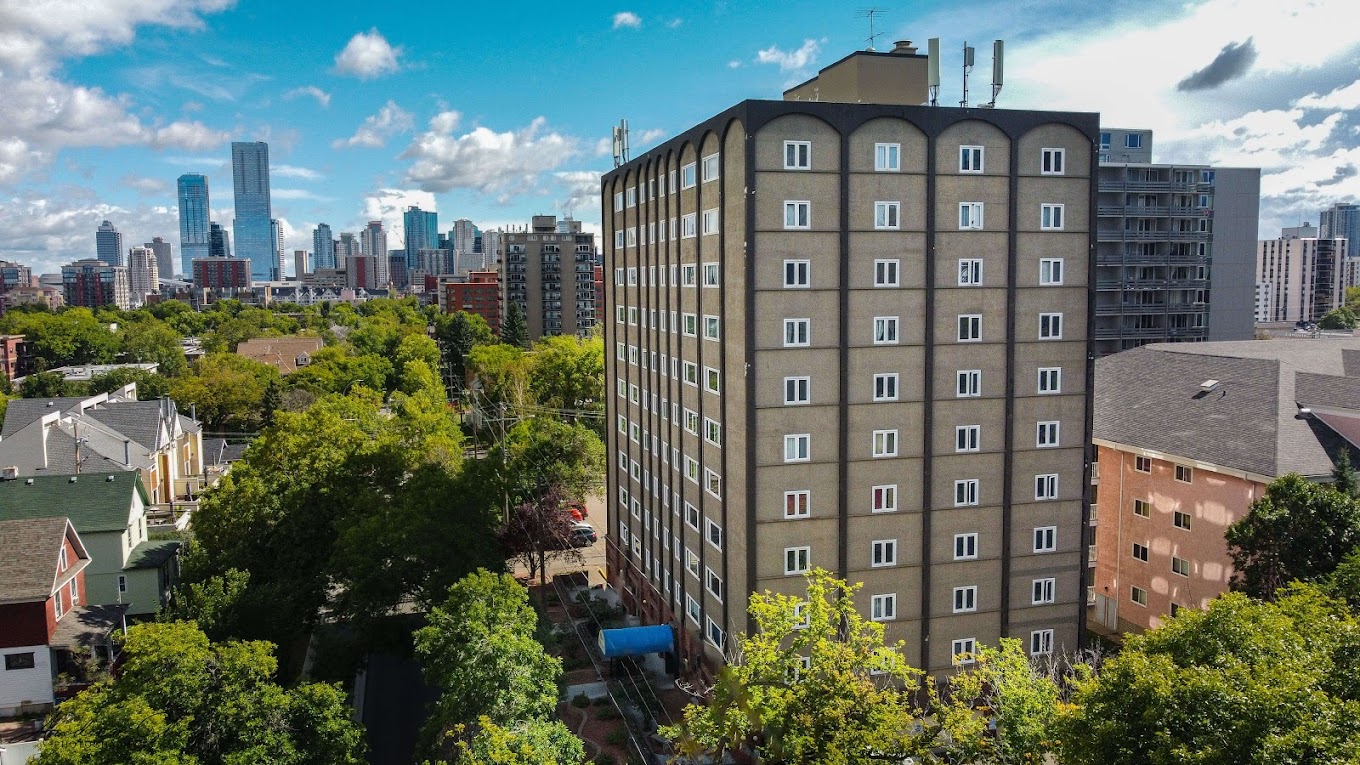
Unveiling a new era in photography, industrial drone photographs offer a unique perspective from the skies, capturing an aerial view. Revolutionizing how we capture images, these aerial shots provide breathtaking views and unparalleled angles. As technology advances, industrial drone photography becomes more accessible, enabling industries to showcase their projects like never before. From construction sites to natural landscapes, these high-flying cameras capture details with precision and clarity in aerial photography and aerial drone view. Embracing the pastime of traditional photography, industrial drone photographs take it to new heights—literally, capturing an aerial view. Witness history being made as these drones redefine the art of aerial view photography.
Key Takeaways
-
Utilize drone photography for marketing: Incorporate aerial view drone imagery in marketing strategies to attract more attention and stand out from competitors.
-
Enhance property mapping and inspections: Improve efficiency and accuracy in property assessments by utilizing drones for mapping, inspections, and gaining an aerial view.
-
Leverage aerial views for real estate development: Utilize aerial perspectives to showcase properties, attract investors, and accelerate real estate development projects.
-
Promote tourism using drone imagery: Showcase scenic views and attractions through drone photography to boost tourism interest and engagement.
-
Explore diverse industry applications: Discover the versatility of drone photography across various industries for tasks like monitoring, surveying, and documentation.
-
Recognize the significance for media and marketing: Understand the value of drone photography, including aerial view, in media production, advertising campaigns, and branding efforts.
Marketing Benefits of Drone Photography
Cost-Effective
Drone photography is cost-effective due to reduced expenses on helicopters or planes for aerial shots. Businesses can save significant amounts while still achieving high-quality marketing materials.
Drones enable companies to capture stunning aerial views without the need for expensive equipment or extensive setup costs. This affordability makes it accessible to businesses of all sizes, from small startups to large corporations.
Versatility
The versatility of drone photography allows businesses to capture aerial view images and videos from unique angles and heights. This flexibility enhances marketing materials, making them more engaging and visually appealing.
Marketers can showcase properties, products, or events in a dynamic and captivating way through aerial footage. This versatility helps companies stand out in crowded markets and attract more customers.
Time-Efficient
Drone photography saves time by quickly capturing aerial shots that would otherwise take longer using traditional methods. Businesses can streamline their marketing campaigns and produce content efficiently.
By utilizing drones, marketers can efficiently gather aerial view footage for promotional videos or advertisements without lengthy setup times. This time efficiency allows companies to stay agile in their marketing strategies.
Enhanced Creativity
The creative possibilities with drone photography are endless, offering businesses the opportunity to create unique and compelling marketing materials. Marketers can experiment with different angles and perspectives to craft visually striking content.
Drone technology enables companies to think outside the box and present their products or services in innovative ways. This creativity sets businesses apart from competitors and leaves a lasting impression on consumers.
Industrial Drone Photography Importance
Efficiency Boost
Industrial drone photography plays a crucial role in enhancing efficiency within various sectors. It allows for quick and accurate data collection, reducing the time and resources needed for manual inspections.
Drones equipped with high-resolution cameras can capture detailed images of infrastructure, machinery, and equipment. This enables businesses to identify issues promptly, leading to faster decision-making processes.
Drones provide a safer alternative for inspecting hazardous or hard-to-reach areas. They eliminate the need for workers to physically access dangerous locations, minimizing risks and ensuring employee safety.
Cost Savings
One of the significant advantages of industrial drone photography is the cost savings it offers to businesses. By utilizing drones for inspections and monitoring tasks, companies can reduce operational costs associated with traditional methods.
Drones are more cost-effective than manned aircraft or manual inspections, making them an attractive option for businesses looking to streamline their operations. Moreover, the data collected by drones can help prevent costly downtime by identifying potential issues early on.
Data Accuracy
The precision and accuracy of data obtained through industrial drone photography are unparalleled. Drones can capture high-quality images and videos, providing detailed insights into the condition of assets and infrastructure.
The data collected by drones is not only accurate but also consistent, ensuring reliable information for decision-making processes. This level of accuracy helps businesses maintain optimal performance and productivity levels.
Environmental Impact
Another significant aspect of industrial drone photography is its positive environmental impact. Drones produce fewer carbon emissions compared to traditional inspection methods, contributing to a greener and more sustainable approach to operations.
Enhancing Property Mapping and Inspections
Efficient Surveys
Conduct detailed property surveys efficiently with aerial drone technology. Drones provide a bird's eye view, capturing precise images of industrial sites. This allows for comprehensive assessments without the need for manual inspection.
Utilizing drones for property mapping offers a time-saving advantage. The technology enables quick data collection over large areas, enhancing efficiency in survey processes. Moreover, drones can access hard-to-reach or hazardous areas, ensuring thorough inspections.
Identifying Issues
Identify potential issues or improvements in industrial structures from above. Drone photography reveals fine details that might be missed during ground inspections. The high-resolution images aid in detecting structural defects or maintenance requirements accurately.
Drone mapping enhances the identification of structural weaknesses or safety hazards. By analyzing aerial footage, inspectors can pinpoint areas needing immediate attention. This proactive approach minimizes risks and ensures timely maintenance interventions.
Streamlining Inspections
Streamline inspection processes by utilizing drone mapping for accurate data collection. Drones offer a systematic approach to inspecting industrial properties, reducing human error. They provide consistent data that can be analyzed for trends or patterns.
Drone technology facilitates real-time monitoring during inspections, allowing for immediate decision-making. Inspectors can assess live feeds to address issues promptly, enhancing overall inspection efficiency. This proactive monitoring prevents potential risks and optimizes maintenance schedules.

Boosting Real Estate Development with Aerial Views
Showcasing Industrial Properties
Industrial drone photography plays a crucial role in showcasing industrial properties to potential investors. Aerial views provide a unique perspective that highlights the scale and features of these properties, giving viewers a comprehensive understanding of the site. By capturing aerial photos and images, industrial drone photography allows investors to visualize the layout, infrastructure, and surroundings of industrial developments.
Enhancing Marketing Strategies
Utilizing aerial perspectives in real estate marketing strategies can significantly boost the attractiveness of industrial projects. These aerial images offer a top view that showcases the entire property, including construction progress, surrounding areas, and access points. Investors can gain valuable insights into the property's potential and suitability for their investment goals through these detailed aerial mappings.
Providing Visual Insights for Investors
Investors seeking opportunities in industrial real estate benefit greatly from aerial perspective provided by drone photography. The ability to view properties from above offers a comprehensive overview of the site, allowing investors to assess factors such as location, proximity to amenities, and overall layout. With sunset or cityscape backgrounds adding aesthetic appeal, aerial views create a compelling visual narrative for potential investors.
Promoting Tourism through Drone Imagery
Showcasing Industrial Beauty
Capture breathtaking aerial views of industrial landscapes to attract tourists. By utilizing aerial drone cameras, you can highlight the unique features and grandeur of industrial sites. For instance, in cities like Bialystok, Poland, drone photography can unveil the hidden beauty of industrial areas that are often overlooked.
Engaging Promotional Material
Create compelling promotional material for industrial tourism using drone imagery. With quality drone photography, showcase the intricate details of factories, warehouses, and manufacturing plants. These images can be used in brochures, websites, and social media campaigns to attract visitors interested in exploring the industrial side of a destination.
Enhancing Visitor Experience
Enhance the visitor experience by offering drone-guided tours of industrial sites. By incorporating drone footage into guided tours, tourists can gain a deeper understanding of the scale and complexity of industrial operations. This interactive approach provides a unique perspective that traditional tours cannot offer.
Applications Across Various Industries
Agriculture Sector
Revolutionize the agriculture sector by monitoring crops and fields with drones. Drones equipped with cameras can capture high-resolution images of farmlands, enabling farmers to detect crop health issues early on. This technology allows for precise application of fertilizers and pesticides, optimizing crop yields.
Drones can also be used to survey large agricultural areas, providing valuable insights into soil health and moisture levels. By analyzing this data, farmers can make informed decisions to improve overall crop production. Drones can help in monitoring livestock, ensuring their well-being and enhancing farm management practices.
Disaster Management
In times of calamity, drones play a crucial role in assisting disaster management efforts by providing aerial surveys of affected industrial areas. These unmanned aerial vehicles can swiftly navigate through hazardous environments, collecting real-time data on the extent of damage caused by natural disasters or industrial accidents.
By utilizing drones, emergency responders can assess the situation more effectively and plan rescue operations accordingly. The aerial footage captured by drones aids in identifying critical areas that require immediate attention, facilitating a quicker response to mitigate further damage.
Infrastructure Development
Drones are instrumental in improving infrastructure development by surveying and mapping industrial sites with precision. These aerial devices can create detailed 3D models of construction sites, enabling project managers to monitor progress accurately and identify any potential bottlenecks in the development process.
Importance for Media and Marketing
Revolutionizing Media Coverage
Industrial drone photography is revolutionizing media coverage by providing dynamic aerial footage of industrial events and activities. Drones capture stunning visuals that were previously impossible to obtain, offering a fresh perspective to viewers. This innovative approach enhances storytelling in media, captivating audiences with unique angles and comprehensive views.
Benefits:
-
Captures inaccessible angles
-
Enhances storytelling in media
Elevating Marketing Campaigns
Drone images of industrial processes are elevating marketing campaigns across various industries. By incorporating aerial shots into promotional materials, companies can showcase their operations in a visually compelling way. These images add depth and authenticity to marketing content, attracting the attention of potential customers and setting brands apart from competitors.
Advantages:
-
Adds depth to marketing content
-
Attracts potential customers
Boosting Audience Engagement
Utilizing visually appealing drone content in media and marketing efforts is crucial for boosting audience engagement. Aerial footage provides a captivating visual experience that resonates with viewers on a deeper level. Whether showcasing large-scale industrial operations or intricate processes, drone photography creates a sense of immersion that keeps audiences engaged and interested.
Key Points:
-
Creates immersive visual experiences
-
Keeps audiences engaged and interested
Closing Thoughts
Incorporating industrial drone photography into your marketing strategy can revolutionize your business. The benefits are immense, from enhancing property mapping to boosting real estate development and promoting tourism. The applications span across various industries, highlighting the importance for media and marketing. By harnessing aerial views, you can elevate your brand and stay ahead of the competition.
Embrace the power of drone photography today to unlock new possibilities for your business. Start exploring how aerial imagery can transform your marketing efforts and propel your brand to new heights. Elevate your visual content with industrial drone photography and witness the remarkable impact it can have on your success.
Frequently Asked Questions
What are the marketing benefits of industrial drone photography?
Drone photography in industries enhances marketing efforts by providing unique aerial perspectives, captivating visuals, and engaging content. It helps attract more attention, showcase professionalism, and differentiate businesses from competitors.
Why is aerial imaging with industrial drone photography and robotic drones important for property mapping, inspections, and thermal camera drones?
Industrial drone photography plays a crucial role in property mapping and inspections by offering detailed aerial views, identifying potential issues, improving accuracy, and saving time. It enables better decision-making, efficient monitoring, and comprehensive documentation.
How does drone photography boost real estate development with aerial views?
By utilizing drone photography, real estate developers can showcase properties from stunning angles, highlight key features, create immersive experiences for potential buyers, and stand out in a competitive market. Aerial views provide a comprehensive overview that enhances marketing strategies.
In what ways does drone imagery promote tourism?
Drone imagery boosts tourism by capturing breathtaking landscapes, showcasing attractions from unique perspectives, creating compelling visual content for marketing campaigns, and attracting more visitors. It helps tourism businesses increase visibility, engage audiences, and drive interest in travel destinations.
What are the applications of industrial drone photography, including aerial mapping and capturing aerial views, across various industries?
Industrial drone photography finds applications in agriculture for crop monitoring, construction for project progress tracking, insurance for damage assessment, and environmental studies for data collection. It offers cost-effective solutions, enhances safety measures, and improves operational efficiency in diverse sectors.
Need more information? check out the following links:
Anthony Shaw photography Home page
Anthony Shaw drone photography page
Andrew Shaw Photography’s Top Resources Regarding Industrial Drone Photography
The Canadian Real Estate Association (CREA) and Drone Usage
Professional Photographers of Canada (PPOC)
ArchDaily – Drone Usage in Architecture